THE 'AUGHRUS LOOP'
Below, we show you around the Aughrus Peninsula Here, we call this route THE AUGHRUS LOOP, though that's not an 'official' name. Of course all of this area is part of The Wild Atlantic Way.
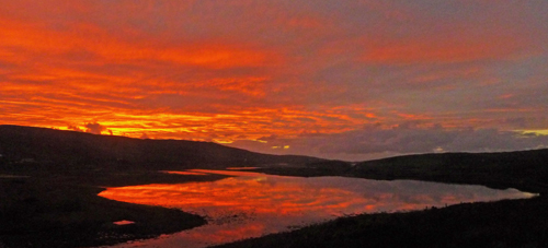
Above: The head of Streamstown Bay, at sunset
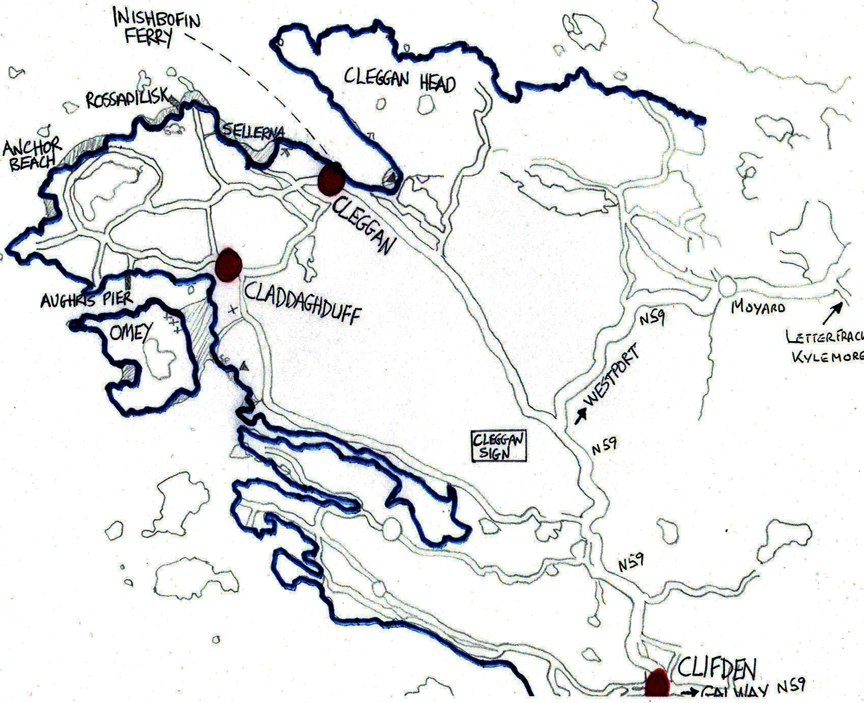
First, a sketch map, to show you some of the main locations. Just click on the link below to download a hand-drawn A4-sized sketch map of the Aughrus Peninsula. Or click the thumbnail below the download link, for an instant illustration.

|
Map of the Aughrus Peninsula.pdf Size : 167.479 Kb Type : pdf |

If you're travelling from Clifden, take the N59 signposted to Westport, and after about 3km take the LEFT turn signposted for Claddaghduff and Omey Island.
If you're traveling from the Westport/Leenane/Kylemore direction, watch out for where the main road takes a 90-degree turn to the left (2km past Cottage Handcrafts, which you will see on your left). See the blue sign advertising Cleggan Fishing Village, and take the right-hand turn signposted for Cleggan and Inishbofin.
This guide assumes you're starting at the turn-off from the N59 for Claddaghduff.
 The drive starts by bringing you along a road right beside the sea - along the northern shore of the narrow inlet called Streamstown Bay. This is a lovely drive in itself, a few km in length. You'll pass an ivy-covered ruined building, which is Doon Fort.
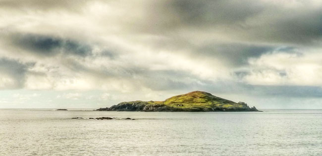
A bit further on, and the Atlantic Ocean opens up ahead of you. The island with the crrags on its right-hand extremity, making it look just like a prehistoric creature of some sort, is Cruagh Island (above) - locally pronounced 'Crow Island'.
Just follow the road, and enjoy the changing view of the Atlantic, with other offshore islands coming into view: Friar Island and High Island, and a bit to the north, Inishark and Inishbofin. To the right is a stretch of flat bogland, with hills yonder.
The three main parts of Friar Island, and behind it High Island
This photo, like the one above, is from Aughrus Point - with the inhabited island of Inishbofin in the distance, and the now-uninhabited island of Inishshark to the left
Soon enough, you'll see the cluster of buildings, with Church, shop/post office and bar, which is Claddaghduff village.
![]() Proceeding down the small road beside the church brings you to Omey Strand and - between approximately half-tide and half-tide - the sand is dry enough to allow you to walk or drive across to the island and look around.
Proceeding down the small road beside the church brings you to Omey Strand and - between approximately half-tide and half-tide - the sand is dry enough to allow you to walk or drive across to the island and look around.
Omey is a really beautiful island, and well worthwhile taking an hour, or preferably much more, to look around. Many people like to picnic there, or swim at the beaches on the island, or just stroll around the perimeter. It's such a lovely place to explore that we provide a separate page to describe more fully the island, and what you can expect to see there - click here to access the Omey Island page.
You may wish to stop for refreshments in Sweeney's Strand Bar (they can advise on tide times for Omey Island, too); and then carry on around the Aughrus Peninsula. The drive will bring you along a picturesque narrow road through the townland of Patches, and then into the much larger townland of Aughrusmore ('big Aughrus').
![]()
At this point, you have two choices - just to stay on the upper road, or to take a left-hand turn which will bring you around a large lake (Aughrus Lake).
We'd recommend the latter - take the LH turn and head around Aughrus Lake. But the upper road gives you fine elevated views also.
If you take the turn left, to follow the lake, you'll be headed towards Aughrus Point. The narroe road left just where the road you're on takes a 90 degree bend to the right, brings you along a cul-de-sac where you can park and walk over rough land and rocks to Aughrus Point.
(Above: Looking north across Aughrus Lake)
Carrying on around the lake will bring you past meadows covered with wild flowers in the Spring (some of the fields are literally covered with pale yellow Cowslips in flower, during the late Spring months). And as the road passes down to run right beside the sea, you'll pass clusters of beautiful small beaches, including the "Anchor Beach" (see the banner picture of this website - and a photo of the anchor itself is to below).
![]()
This is Aughrusbeg ("Little Aughrus") which includes the locally known Anchor Beach, named after an old anchor lying there, a relic of the "Verity", a three-masted 1,000 ton barque built in Quebec in 1898 and wrecked off Aughrus Point just a year later, in January 1890, with the loss of two lives - read the fully story HERE.
This is just one of the lovely places to swim, and a favourite for families with children, since the sea is (almost) always calm, and the beaches safe.
![]() If you choose the upper road, rather than looping around Aughrus Lake, you'll have elevated views of the ocean and the offshore islands.
If you choose the upper road, rather than looping around Aughrus Lake, you'll have elevated views of the ocean and the offshore islands.
High Island, which in the seventh century was a penetential outpost of the Omey Island monastery, founded by St Feichin The photograph above (and that below) was taken at sunrise, from the top of Aughrus Hill, an easy climb from the upper road.
![]()
Continuing on around the peninsula, in the direction of Cleggan, you will see the salt-water lake Lough Atalia opening up before you - it is in fact part of the sea, and not a lake.
Carrying on a little further in the direction of Cleggan village, you'll see a left turn signposted to Rossadilisk - the tiny village and fishing harbour of Rossadilisk was the place from which some sixteen men were lost, in the so-called Cleggan Bay Disaster of 1927, which also claimed the lives of many men from Inishbofin and from Co Mayo. You can walk onto the strand from the end of the road (just before the cluster of houses at the end), and all the way around, past the harbour.
![]() Turning right on the way down to Rossadilisk (see the sign for Rossadilisk House and Lacey's Cottage), you will come to Tra Bhride (Brid's Beach), a really beautiful spot looking across Cleggan Bay, out towards the islands, and up to the head of the bay and on to the Twelve Pins mountain range.
Turning right on the way down to Rossadilisk (see the sign for Rossadilisk House and Lacey's Cottage), you will come to Tra Bhride (Brid's Beach), a really beautiful spot looking across Cleggan Bay, out towards the islands, and up to the head of the bay and on to the Twelve Pins mountain range.
![]() Back onto the main road, and further along, just by the white sign marking the boundary of Cleggan village, a left turn signed "Tra" (which means Beach in Irish) brings you to the large sweep of Sellerna Beach. There is an ancient dolmen, dating to before the Great Pyramid, in the fields just beyond the beach.
Back onto the main road, and further along, just by the white sign marking the boundary of Cleggan village, a left turn signed "Tra" (which means Beach in Irish) brings you to the large sweep of Sellerna Beach. There is an ancient dolmen, dating to before the Great Pyramid, in the fields just beyond the beach.
There is grand swimming to be had from Sellerna Beach, and families with young families enjoy spending summer days there.
So to Cleggan village itself, with its working fishing harbour. For provisions, there's Cleggan Stored, and food is available in Oliver's, in the Pier Bar, and in The Crafty Crab (Joyce's Bar).
The ferry to and from the island of Inishbofin plies from Cleggan Harbour; and the Citylink bus service connects Cleggan to Letterfrack, Clifden and Galway city.
Cleggan Harbour - the inner part - was designed and constructed by the famous engineer Nimmo - who oversaw so much construction in the area, including Clifden town itself. To protect small vessels from the scend entering the harbour during strong NW or SE winds, a boom (series of strong planks) is sometimes fitted, to form a closed-in harbour 'pool'.
![]()
Passing straight through Cleggan Village, on a 'bog road' passing bogland and 'eskers' of gravel (deposits from melting glaciers at the end of the Ice Age) and stands of spruce and pine, in about 5km you will return to the N59 main Clifden-Westport road; and you have then completed the AUGHRUS LOOP. We hope you enjoyed it!